
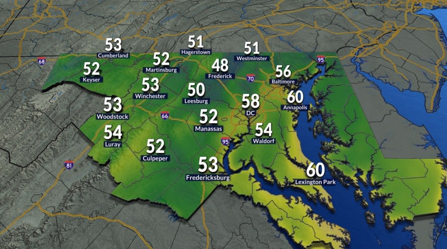
Residents across the Washington, D.C., metropolitan area woke up to an invigorating change in the atmosphere on Tuesday morning as the first true taste of autumn swept into the region. Following months of persistent summer warmth, early morning temperatures dropped into the 50s, creating an uncharacteristically cool environment that caught many local commuters by surprise.
The dip into the 50s marks a significant meteorological milestone for the nation's capital. Local weather records show that Washington had not experienced morning low temperatures in the 50s since June 3rd. That prolonged stretch of elevated overnight readings underscored just how long mid-Atlantic residents have endured summer’s unwavering grasp before this week's welcome reprieve.
The crisp early conditions prompted many morning travelers across the district and surrounding suburban corridors to reach for light jackets and sweaters for the first time in over three months. The brisk air provided ideal conditions for early morning exercise, school commutes, and outdoor activities that had previously been hampered by high heat and oppressive dew points.
As the morning progressed, the initial chill gave way to an exceptionally pleasant Tuesday afternoon. Under abundant sunshine and remarkably low humidity, regional temperatures rebounded comfortably, settling into the upper 70s to lower 80s. The combination of dry air and mild warmth created some of the most comfortable weather conditions the area has recorded in recent memory.
Meteorologists indicate that Wednesday will continue the favorable pattern, offering another cool and comfortable start to the day. While Wednesday morning is expected to be brisk, minimum temperatures are projected to sit slightly higher than the notable lows recorded on Tuesday morning, providing a gentle moderation across the region.
Wednesday afternoon is slated to remain bright and dry, with mainly sunny skies persisting throughout the daylight hours. Afternoon highs will inch slightly higher than Tuesday's readings, with thermometers expected to reach into the lower to mid-80s, delivering another ideal day for outdoor dining, recreation, and regional transit.
Forecasters advise residents throughout the greater Washington area to make the most of both Tuesday and Wednesday. The extended stretch of dry, crisp air and moderate temperatures represents a brief seasonal preview before more summer-like humidity and elevated warmth make a noticeable push back into the mid-Atlantic by the end of the week.
A noticeable shift in the broader pattern will begin taking shape on Thursday. Increased atmospheric moisture will push humidity levels upward, while partly sunny skies will allow daytime high temperatures to climb into the upper 80s. The warmer, stickier air will quickly replace the crisp, dry conditions that characterized the earlier half of the workweek.
By Friday, unsettled weather will accompany the returning warmth as a cold front steadily advances toward the region from the northwest. Daytime high temperatures are once again forecast to surge into the upper 80s amid elevated humidity levels, creating an increasingly unstable atmosphere across the district, Maryland, and Northern Virginia.
The approaching frontal boundary is projected to trigger convective activity during the latter half of Friday. Regional forecasts call for isolated showers and thunderstorms to develop during the afternoon and evening hours, which could potentially impact the Friday evening commute and early weekend outdoor gatherings across the metropolitan area.
Following the passage of the cold front, conditions will moderate slightly over the weekend. Both Saturday and Sunday are forecast to see daytime highs settle in the mid-80s across the region, reflecting a modest cooldown from the peak heat experienced during Thursday and Friday afternoon.
Although temperatures will remain fairly consistent throughout the weekend, Sunday carries a higher probability of precipitation than Saturday. Forecasters note an increased likelihood of showers and thunderstorms developing on Sunday, which may require residents with weekend travel or outdoor recreation plans to keep a close eye on updated local radar reports.
The subsequent workweek will begin on a milder, cloudier note. Monday's forecast indicates that daytime high temperatures will hold around 80 degrees under predominantly cloudy skies across the Washington area, offering a calm prelude to the impending change of the calendar.
The entire week of fluctuating temperatures serves as a dynamic transition leading up to the official start of astronomical fall next Tuesday. As the region navigates brief bouts of summer humidity alongside early autumn chills, the broader seasonal pattern confirms that cooler, crisper weather will soon become a permanent fixture across the capital.






(0)