
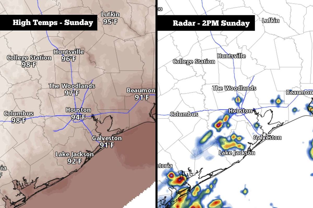
Residents across the Houston metropolitan area should prepare for a mix of scorching temperatures and intermittent storm activity to close out the weekend, as an influx of tropical Gulf moisture moves across Southeast Texas. While the regional forecast calls for scattered showers and thunderstorms on Sunday, meteorologists note that the precipitation will remain unevenly distributed across the region.
The incoming moisture provides a modest opportunity for rainfall following an uncharacteristically dry stretch for the local area. Although Southeast Texas enjoyed a noticeably rainy spring and a wet start to the summer season, the regional pattern shifted abruptly toward drier conditions over the past two months.
Official climate data highlights that since July 15, Houston has collected a mere 2.55 inches of cumulative precipitation. That amount accounts for only 30 percent of the typical rainfall baseline normally recorded during that mid-to-late summer interval, leaving regional soils increasingly parched.
Sunday began on an unseasonably mild and humid note, with early morning temperatures lingering around 80 degrees across the metropolitan area. This warm baseline stands in stark contrast to mid-September climatological norms, which typically feature overnight low temperatures hovering closer to a cooler 72 degrees.
As the morning progresses, intense sunshine and rich moisture are set to drive temperatures upward at a rapid pace. Thermometers across the Houston area are anticipated to climb to the 90-degree mark as early as 11 a.m. before peaking near 94 degrees during the early-to-mid afternoon hours.
Elevated dew points will amplify the ambient heat significantly, creating uncomfortable conditions for anyone spending extended periods outdoors. Meteorologists anticipate afternoon heat index values, which measure how hot the combination of temperature and humidity feels to the human body, will reach between 103 and 105 degrees across the metro area.
Along with the intense heat, the primary weather feature on Sunday will be the emergence of scattered showers and isolated thunderstorms. The atmospheric disturbance is being driven primarily by deeper Gulf moisture surging inland from the southeast, setting off convective activity during the warmest hours of the day.
Overall, rain probabilities across Houston are projected to range from 30 to 40 percent throughout Sunday. The most favorable window for thunderstorm development will occur between noon and 4 p.m., after which storm coverage will diminish, with precipitation chances dropping under 20 percent by the early evening.
Because the anticipated storm activity will be spotty rather than widespread, total precipitation figures will remain modest for the vast majority of local communities. Most neighborhoods that experience rainfall can expect accumulation totals below a quarter of an inch, though isolated downpours could briefly produce localized totals of half an inch or more alongside gusty winds.
Given the isolated distribution and limited accumulation potential of the incoming showers, forecasters emphasize that the flood threat remains exceptionally low across the entirety of Southeast Texas throughout the weekend.
The broader synoptic pattern suggests that Houston will remain locked in this hot, humid weather regime as the new workweek begins. A persistent, stalled high-pressure system positioned just to the east of Texas will continue to influence regional conditions through Wednesday.
Under the influence of this high-pressure ridge, daily afternoon high temperatures between Monday and Wednesday are forecast to range between 92 and 94 degrees. When paired with unusually stubborn mid-September humidity levels, apparent temperatures are forecast to climb into a dangerous heat index range of 105 to 107 degrees each afternoon.
Rain opportunities during the first half of the workweek will remain minimal and short-lived. Forecasters expect daily afternoon shower and storm probabilities to hold between 20 and 30 percent from Monday through Wednesday, with any cells that manage to develop dissipating rapidly.
Slight atmospheric changes are anticipated toward the tail end of the week as the persistent high-pressure ridge begins to weaken. This subtle decay will permit afternoon high temperatures to ease slightly to around 91 or 92 degrees on Thursday and Friday, while convective storm chances experience a minor increase.
Looking ahead to next weekend, long-range numerical weather models indicate that a potential cold front could advance toward Texas. However, current projections suggest the frontal boundary is likely to stall out before penetrating the immediate Houston area, meaning it will likely fail to deliver a significant reduction in regional temperatures, though it could trigger a few additional storms as it nears.





(0)